Description of Land
The sand beach is 2,230 feet long, and on average 60 feet wide. The sand is coral sand produced through the deterioration of coral reefs by wave action.
The sea immediately offshore is fairly shallow. On average, the depth 4,000 feet offshore is 3 fathoms , and the depth at 16,000 feet offshore is 100 fathoms . The water offshore at the western end of the property is shallower than that to the east, as a result of natural sand build-up against Bluff Point.
The nearshore marine area has two major substratum types, sand and seagrass (largely turtle grass, thalassia testudinum). The quality of the sea water is excellent.
Farther offshore, the prevailing water depths range between 200 and 300 fathoms, but there are numerous banks rising to less than 20 fathoms. These banks provide considerable protection from wave action, and Bluefields Bay is typically very calm.
In addition, Belmont Point to the east of Paradise, and the mountains above Bluefields, which rise to 2,300 feet above sea level, shelter Bluefields Bay and Paradise Park from the prevailing winds from the east. Bluefields Bay faces westerly and southerly, so that Paradise is protected from prevailing meteorological and oceanographic phenomena, including the westerly littoral current running along the southwest coast of Jamaica.
The major source of waves and swells are the trade wind systems, plus occasional storms and easterly waves. The bulk (measured at 61%) of open sea waves travel from the east. Due to the position occupied by Paradise Park, waves would have to refract around the south west coast of the island before reaching shore.
Recent hurricane history is anecdotal. In 1988, Jamaica experienced a direct hit from a category 4 hurricane, Hurricane Gilbert. That hurricane generated high tides of 1.6 feet above normal for 24 hours, with no noticeable shoreline deterioration. Hurricane Ivan, a category 4 hurricane in 2004, passed approximately 40 miles south of Paradise, and produced a sea swell of approximately 1.6 feet, and resulted in significant enhancement of the beach. Hurricane Dean in 2007, also a category 4 hurricane, passed 50 miles south of Paradise, and produced no significant sea swell or high tides, and otherwise had little effect on the property.
Tides are diurnal, with one high tide and one low tide each day. The mean range of the tide is 1 foot.
Pristine coral reefs lie offshore to the east and west of the opening to Bluefields Bay. A shipwreck lies near the reef to the west of Paradise. The area is ideal for snorkeling and diving.
A beach development study commissioned by Paradise Park indicates that the bay contains sand in sufficient quantities, and within economic distance, to substantially widen and lengthen the existing beach by pipeline dredging. If sand were pipeline dredged from just offshore onto the beach, no vegetation would have to be displaced and the increased water depth would enhance swimming. As well, the fact that there is no shallow reef immediately opposite Paradise is likely to facilitate the replenishment of sand.
Mean monthly rainfall has been measured at 7.6 inches 193 mm and mean average temperature is 79 degrees Fahrenheit.
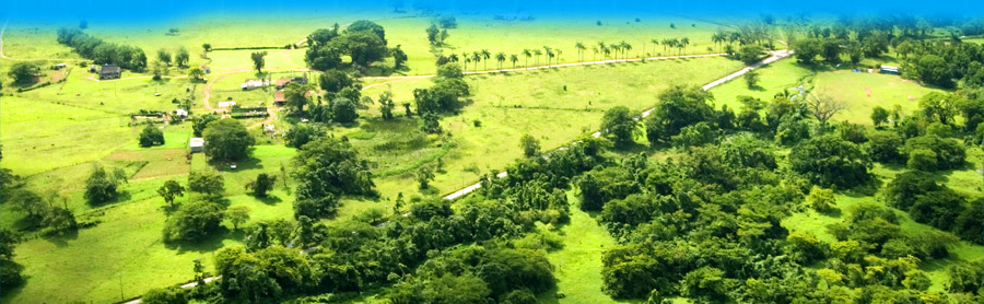
The land is low-lying coastal plain, currently largely in pasture and secondary bush. The land also includes mangrove swamp, parts of which could be an appropriate area for effluent treatment and disposal.
The topography of Paradise Park is low-lying coastal plain. Closer to the sea, there are a series of curved, vegetated former beach ridges aligned to the present shoreline. These ridges are comprised of sand of marine origin, and indicate that, in terms of the recent geological history of the land, the beach and shoreline have increased and advanced towards the sea over time.
The estates Bluff Point is anchored at the core by rock. The western side of Bluff Point is highly sheltered from the prevailing winds, and could be used for a marina and/or a port. In times past there was a logwood pier on the western side of Bluff Point.
The Paradise Estate has four rivers which run from the north side of the property into the Caribbean Sea. These include two tributaries of the Sweet River. A water flow measurement report indicated that the ordinary total river flow available on Paradise Park property was in excess of 10.9 million Imperial Gallons per day (IGPD), but water flow varies considerably during the year, with higher flow rates between June and October.
A spring on the estate, lying approximately 50 feet above mean sea level, produces an estimated 6.25 million IGPD, of which 4.96 million IGPD is available for use by Paradise Park. Water flow from the spring also varies seasonally.
The land is comprised mainly of pasture land with some large, old trees including silk cotton (Ceiba pentandra) and broadleaf (Terminalia latifolia.) Nearer to the sea, coastal woodlands contain sea grape (Coccoloba uyifera), seaside mahoe (Hibiscus tiliaceus) and buttonwood (Conocarpus erectus) trees.
The property contains three different types of wetlands: mangrove swamp, swamp forest and freshwater marsh. Stands of royal palms (Roystonea principe) are well-developed and accessible.
print page